


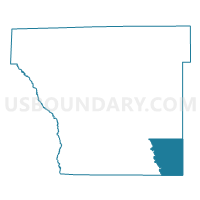
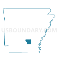
Hurricane Voting District, Cleveland County, Arkansas
About
Outline

Summary
| Unique Area Identifier | 526183 |
| Name | Hurricane Voting District |
| County | Cleveland County |
| State | Arkansas |
| Area (square miles) | 27.61 |
| Land Area (square miles) | 27.49 |
| Water Area (square miles) | 0.12 |
| % of Land Area | 99.57 |
| % of Water Area | 0.43 |
| Latitude of the Internal Point | 33.75147970 |
| Longtitude of the Internal Point | -92.01381130 |
Maps

Graphs
Select a template below for downloading or customizing gragh for Hurricane Voting District, Cleveland County, Arkansas


Neighbors
Neighoring Voting District (by Name) Neighboring Voting District on the Map
- Harper Voting District, Cleveland County, AR
- Lee Voting District, Cleveland County, AR
- Mill Creek Voting District, Lincoln County, AR
- North Pennington Voting District, Bradley County, AR
- Plantersville Voting District, Drew County, AR
- Redland Voting District, Cleveland County, AR
Top 10 Neighboring County Subdivision (by Population) Neighboring County Subdivision on the Map
- Pennington township, Bradley County, AR (8,415)
- Redland township, Cleveland County, AR (622)
- Clear Creek township, Drew County, AR (551)
- Harper township, Cleveland County, AR (538)
- Hurricane township, Cleveland County, AR (528)
- Lee township, Cleveland County, AR (407)
- Mill Creek township, Lincoln County, AR (317)
Top 10 Neighboring Place (by Population) Neighboring Place on the Map
Top 10 Neighboring Unified School District (by Population) Neighboring Unified School District on the Map
- Star City School District, AR (9,208)
- Warren School District, AR (8,676)
- Drew Central School District, AR (6,353)
- Cleveland County School District, AR (5,521)
- Woodlawn School District, AR (2,849)
Top 10 Neighboring State Legislative District Lower Chamber (by Population) Neighboring State Legislative District Lower Chamber on the Map
Top 10 Neighboring State Legislative District Upper Chamber (by Population) Neighboring State Legislative District Upper Chamber on the Map
Top 10 Neighboring 111th Congressional District (by Population) Neighboring 111th Congressional District on the Map
Top 10 Neighboring Census Tract (by Population) Neighboring Census Tract on the Map
- Census Tract 4905, Drew County, AR (4,082)
- Census Tract 9702, Cleveland County, AR (3,794)
- Census Tract 9604, Lincoln County, AR (3,582)
- Census Tract 9501, Bradley County, AR (2,499)